
Driving the 49 Mile Drive
The Long Walk—in a car
Monday, 4 July 2011
We started the Drive at the Civic Center, in front of the Asian Art Museum. This time we would go in the specified direction, and from the correct starting point. Would we see big differences between our Long Walk and the car drive?
We guessed beforehand how long the drive would take, and three hours seemed as good a guess as any. We also set the odometer to zero to see if the route is 49 miles long.
We brought our trusty American Automobile Association “San Francisco Guide Map” which shows the route. However, we planned on following the famous seagull signs, which is what we think the typical tourist would do.
We started out going north on Larkin and of course immediately entered the Tenderloin. Not the best start. The seagull signage was good, though, and we had no problems. Except that we couldn’t pull the car over to take pictures in most places due to traffic, no stopping zones and the like.
At Geary we went west, out to Japantown, and then back in on Post. Nothing really jumped out. At this point people who do not know what to expect would begin wondering if they should continue with the Drive. That’s what we were thinking. Also, the Drive looked like it might take five hours at this point—our pace was very slow.
Moving on down past Union Square to Grant, and then up through the lions to Chinatown—one thing we noticed was that Grant and Stockton should not be confused. With the Drive, tourists only see shops that sell trinkets such as license plates that say “Simon” on them. Moving north on Grant, it became clear that when we were behind a truck or a tour bus, there wasn’t much to see, except the back of the truck or bus. Another drawback to not walking.
Then it was up California to the top of Nob Hill. Lots of history here, but who would know that without a good guidebook? The seagull signs were still providing guidance on where to turn.
Then back down the hill and out Kearny to Columbus. A sort of tricky left turn, transition to a right turn at Grant, waved at City Lights, but still things were ok. Until we got to Lombard. There should have been a seagull sign here, directing the driver to turn left. At this point some drivers probably abandoned the trip. We had the map and turned left.
We were going to Fisherman’s Wharf and when we got there, it was a shock. Lots and lots of tourists appreciating San Francisco and its collection of tee shirt shops. Waved at Hooter’s and kept going. More tourist buses to drive behind. Up to Fort Mason, so far, so good in terms of not getting lost.
On Marina Boulevard, the seagull said we should turn right into a parking lot, and we did. But it is a dead end. What to do? Oh, on the other side of Marina (on Scott) there was another seagull. Perhaps the idea is to not have people turn left directly onto Scott. Anyway, we went up Scott, and worked our way past the Palace of Fine Arts and moved on into the Presidio.
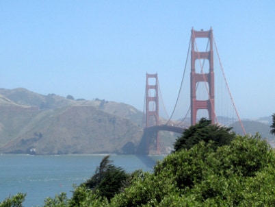
That’s where the signage breaks down. It could be due to Doyle Drive reconstruction or all of the work in the Presidio, but the signs disappear and there was no clue as to what to do. We had the map, and after about a dozen wrong turns got up to the Golden Gate Bridge and started down Lincoln Boulevard. No seagulls in several miles now.
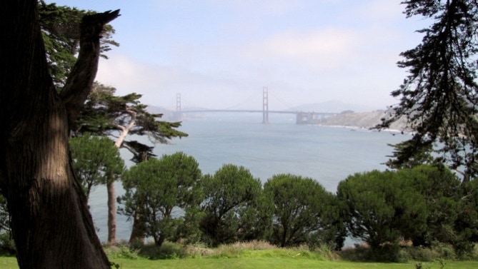
We finally found a good place to pull over for a picture. That’s the one above. A bit further on, we had another chance.
At the Palace of the Legion of Honor the signs were back in evidence, and we decided it was time for lunch. We noted the odometer reading, and stopped the clock while we drove to a restaurant back on Union Street.
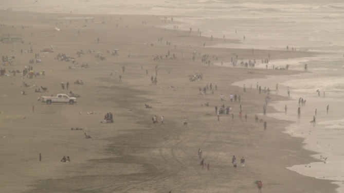
After lunch we drove back out Geary to 34th Avenue and started the Drive again. The temperature was falling and the fog was visible. We stopped at the Cliff House to admire the crowd at Ocean Beach celebrating the holiday while the temperature was 56F.
We headed south down the Great Highway towards the zoo. Before we reached the intersection of Skyline and John Muir, the seagull said to use the left lane. That really means, I found out, to stay in the lane and if forced to turn, turn. After going past the intersection by about a quarter of a mile, we did a U–turn.
At this point, we were circling Lake Merced, just as we did last month. Going back up Lake Merced Boulevard, past the Praying Penguins, it was hard to see the lake from the car. The seagull signs were fine in this area.
Then we went north on Sunset, back towards Golden Gate Park. In the park, the seagull signs went Missing In Action. We knew the route, but those without a map would be lost. Waved at the De Young Museum (not on the Drive) and pressed on towards the Upper Haight. I think the seagull sign was missing at Stanyan, another mistake.
Up the hill to Parnassus, and then along Laguna Honda. The signage to get up into Twin Peaks was less than desirable. It’s possible that following a sign that instructed the driver to stay in the left lane would do the trick. But there is a confusing intersection at Portola, and who knows what drivers would do at that point.
Up Twin Peaks and the nice view, with some seagull signs missing. Then we went back down the hill towards Mission Dolores. We were surprised to see what must have been thousands of people in Dolores Park. The park gets a lot of use on holidays.
Then south to the brutal Cesar Chavez. The signage approaching the Bayshore Freeway wasn’t good, but we just drove straight on. Before getting to Interstate 280, the seagull said to follow 280 North. At Pennsylvania, it looked like the seagull was directing us to continue a bit and then turn left. But the 280 sign said to turn left, so we did. Mistake. We figured it out and got on the freeway towards downtown. The view from the elevated freeway is pretty good. We missed that on the walk.
We got off the freeway at King Street, and worked our way towards the Embarcadero. The signage was good, and the waterfront was pretty. The temperature now was 67F.
At Washington we turned left (didn’t see a sign) and went up to Battery, where we turned left to get across Market and over to Howard Street.
Out Howard, and to the turn onto Ninth Street. From there it was a short run over to the Asian Art Museum and the end of the Drive.
The elapsed time of the Drive was 2 hours, 58 minutes. Length of the journey was 47.8 miles.
General comments for whoever is in charge of the 49 Mile Drive:
1) Immediately launching the trip by going into the Tenderloin is a turn off.
2)The signage in the parks is bad, really bad.
3)It’s tough being the driver and looking for the seagull signs. Not much time to see the scenery. Some of the signs are not in the best spots.
4)Walking the route is much better than driving it. No comparison, actually.
5)What happened to the missing mile?
Now we are going to figure out a better walk through San Francisco, and give it a go. There is a lot missing from the Drive. For instance, Pacific Heights, Alamo Square and the Richmond District. What’s with McLaren Park in the southeast? We’ve heard it’s worth a look, so it’ll probably end up on the list.
Rather than have a continuous walk, we might try something different next time to see neighborhoods in depth. For example, walking around inside the Presidio, not through it.
Suggestions from readers will be cheerfully received.
We thought today would make a good day to drive the 49 Mile Drive, for comparison purposes. So we set out for Civic Center and the starting point.